Garmin Oregon 450t Review
A look back at Garmin's 2010-era touchscreen GPS handheld — still functional for backcountry navigation, but showing its age.
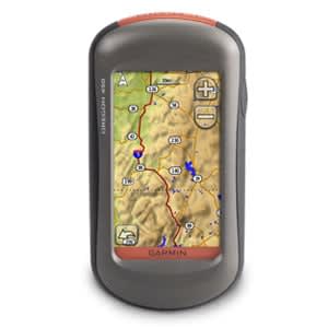
Overview
The Oregon 450t was Garmin’s mid-tier touchscreen handheld GPS, released back in early 2010 as part of the Oregon x50 lineup. It’s aimed at hikers, hunters, and geocachers who want dedicated, button-free satellite navigation with preloaded topo maps rather than relying on a phone. These days you won’t find it new — it’s a discontinued unit you’ll mostly encounter secondhand on eBay or in the back of a gear closet — but it still shows up often enough in used-gear discussions that it’s worth understanding what you’re getting.
Key Specs
| Spec | Value |
|---|---|
| Weight (with batteries) | 192.7 g (6.8 oz) |
| Weight (without batteries) | 146 g (5.1 oz) |
| Display | 3” transflective color TFT touchscreen, 240x400 px |
| Waterproof rating | IPX7 |
| Battery | 2x AA (not included) |
| Battery life | ~16 hours |
| Built-in memory | 850 MB |
| Expandable storage | microSD slot |
| Dimensions | 2.3 x 4.5 x 1.4 in |
| GPS accuracy | ~33 ft (10 m) |
| Waypoints / Routes / Track points | 2,000 / 200 / 10,000 |
Would the Oregon 450t earn its spot in your pack?
193 g · 6.8 ozAdd the Garmin Oregon 450t to your gear closet and see exactly what it does to your base weight — then build your next packing list around it. Free, in about two minutes.
Free · No credit card · iOS & Android · Trusted by 3,000+ backpackers
Performance
The core GPS performance on the 450t has held up better than its interface has. Users on SummitPost report using the Oregon 450t on many cross country treks and climbs with Garmin 24k maps and OSM maps, describing it as very accurate, with only occasional signal hiccups — the receiver has occasionally failed to maintain a connection with the satellites, usually in rocky yet open terrain. That’s a reasonable trade-off for a 2010-era chipset; modern units and phone GPS chips generally lock faster and hold signal more reliably in canyons and under tree cover, but the 450t isn’t going to leave you stranded under normal hiking conditions.
Battery life is a genuine strength. One long-term user reported a reasonably good battery life — a full day on fully-charged alkalines, assuming the backlight is off, which lines up with Garmin’s spec of about 16 hours. Swap in lithium AAs and you’ll stretch that further, plus they perform better in cold weather where alkalines sag. That’s the beauty of AA-powered devices: no proprietary battery to degrade over 15 years, and you can always find a spare pair at a gas station.
The touchscreen is the unit’s most divisive feature. It’s genuinely useful for things like typing waypoint names and panning around the map — reviewers note typing in long waypoint names is a breeze, and the ability to scroll through the map by swiping lets you look ahead terrain-wise and even change scale while browsing away from your current position. But it comes with real downsides in the field. Cold weather is the biggest complaint: the Garmin touchscreen does not work very well in very cold weather, or you have to keep it inside your jacket to get it to work. It’s also slower for quick glances than the old button-based Garmin units — some features are slower to access using the touch screen compared to button systems, since you have to hit the menu button first and then find the screen you want and tap it, whereas older Garmins let you rapidly page through screens with a single button press.
Screen visibility is another mixed bag. It was actually an improvement for its era — once different viewing angles were tried, it became clear the 450 was viewable over a wider range than the older model — but that improvement was mostly conditional. The difference is seen in sunny, bright conditions only, with little detectable difference in shade. A more recent used-buyer echoed this today: the only negatives are the brightness, even at its best is hard to read in direct sunlight, and the weight for those looking to cut ounces. If you’re used to a modern phone screen or even newer Garmin sunlight-readable displays, expect to squint on bright ridgelines.
The “t” in 450t means it ships with 1:100,000 scale US topo maps preloaded, but multiple reviewers argue this is the weakest reason to pick this model over the cheaper base 450. As one long-tenured GPS reviewer put it, the 450t’s preloaded topo maps of the entire US may appeal to those who travel a lot, but there are better quality 1:24,000 scale topo maps available for free for most states, via sites like GPS File Depot. Another reviewer bluntly noted that with the stock 1:100k maps you cannot do any routing — you need the pricier 1:24k regional maps for that. So unless you specifically need out-of-the-box, no-fuss US-wide topo coverage, the money spent on the “t” premium is arguably better spent on aftermarket maps for the base 450.
Elevation tracking, a common weak point on older Garmins, seems to have been fixed by the time the 450 series shipped — one tester found the Oregon 400t, 450, and a 60CSx were all within 2% of each other in reported elevation gain after initially expecting the newer unit to be less accurate.
Pros & Cons
Pros
- Solid, accurate GPS lock for backcountry use, per long-term field reports
- Runs on 2x AA batteries — easy to resupply on trail, good cold-weather flexibility with lithiums
- ~16-hour battery life is competitive even by today’s standards
- Touchscreen is genuinely handy for waypoint naming and map panning
- IPX7 waterproofing and a rugged, pocket-friendly form factor
- microSD expansion plus 850 MB onboard storage is plenty for vector topo maps
Cons
- Touchscreen struggles or stops responding in cold temperatures
- Slower to navigate menus for quick glances compared to old button-based Garmins
- Screen brightness is mediocre in direct sunlight
- Preloaded 1:100k topo maps are low-resolution and can’t be used for routing
- Discontinued — no longer sold new, so you’re buying used and hoping the unit and battery contacts have aged well
- At 192.7 g, it’s noticeably heavier than a phone you’re likely already carrying, with none of the multi-use benefits
Who Should Buy This
This one’s really for a specific buyer: someone who wants a dedicated, phone-independent GPS unit, doesn’t mind sourcing it used, and is comfortable loading better free maps onto it rather than relying on the stock topo set. It also suits cooler-but-not-frigid climates, since the touchscreen’s cold-weather quirks are a real limitation for winter mountaineering or shoulder-season alpine trips. If you’re a geocacher or hunter who wants dedicated hardware as a satellite-signal backup to a phone, it still does the job.
Verdict
The Oregon 450t was a genuinely good touchscreen GPS for 2010, and the core GPS/battery performance has aged reasonably well — but the screen, cold-weather touchscreen quirks, and dated preloaded maps make it feel every bit its age. If you already own one, or find a clean used unit cheap, it’s still a competent backup navigator loaded with better free maps. If you’re shopping new for a dedicated GPS today, though, you’ll get a brighter screen and faster interface from Garmin’s current handhelds — I’d rate this one a 6/10, mostly on the strength of its battery life and rugged simplicity.